Documents
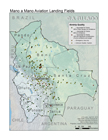
Landing Fields Map
April, 2012
All of the air strips in use by Mano a Mano Aviation for medical evacuations are displayed according to the quality of the landing field, allowing for analysis of alternative routes during times of limited resources or poor weather conditions.
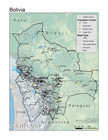
Bolivia Base Map
January, 2012
Bolivia is shown here with the basic elements of its physical geography, population distribution, and infrastructure (including roads and health centers), providing a basemap for future geographic analysis projects. A Tu Lado is using this to develop maps displaying epidemiological information, flight routes, and communication systems in order to improve the efficiency and efficacy of Mano a Mano's Aviation's medical flight service.
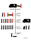
SMS Response System
Updated May, 2012
Basic design of an SMS response system designed in collaboration with Venemergencia. The system was designed to allow a brigade of first responders to communicate internally, and receive emergency calls from community members.

